

For arts and culture organizations, a great deal of data is geographic in nature. There are audience and donor zip codes, as well as specific neighborhoods impacted by institutional outreach. Collection pieces are often tied to a certain time and place, as are artists’ stories and inspirations. An organization may have a lot of this data, but how can they best harness it to contextualize their work and convey a compelling story? Combining geographic information, multimedia content, and text narrative, Esri’s Story Maps is a tool that can support an organization with exactly this kind of place-based storytelling.
Story Maps Overview
Created by Esri, a leader in geographic information systems (GIS) software, Story Maps are a series of web applications that combine interactive maps, text, and multimedia content to tell stories. Story Maps are free and open source so long as you create an ArcGIS public account.
This program is compatible with both PC and Mac, and it is built on a platform that is mobile-friendly, so any content generated responds to various screen displays.
One of the nicest features of Story Maps is its user-friendliness. This digital platform comes with built-in functions that allow arts managers and other cultural workers with no GIS or web development skills to create and share exciting stories online about their organization’s work. Additionally, Esri offers many free, online resources for Story Map beginners. They have lesson plans, and they also provide a helpful video on how to best tell your story using their apps.
Story Maps App Templates
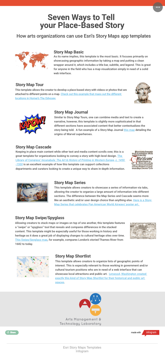
There are seven Story Map app templates, meaning there are several designs from which one can choose to embed multimedia content, such as photos and video, as well as interactive maps to tell a story. Below is an infographic explaining each the different templates , with links to arts and culture cases that highlight their various features. This is another benefit of the platform; as everything is open source, there are many examples from which creators can draw inspiration.
Story Maps’ Limitations
While Story Maps offers a variety of templates that can meet different storytelling needs, the platform does have some limitations. Here are things to consider before using this tool:
Users should be aware that Story Maps is an open source web application stored on the ArcGIS online cloud. Cloud storage systems, in general, present a data security risk. This is something to keep in mind, particularly if the data you are using to create your Story Map is connected to sensitive internal information. See Esri’s Story Maps’ FAQ page, as well as their terms and conditions for further details.
Some aspects of each app template are not customizable. For example, there are areas where text can be entered, but a line break to make said text more aesthetically pleasing cannot be done in a web browser. It should be noted that all of the source code is listed on GitHub where it can be downloaded and edited, but for novice user, customization remans restricted.
Unlike other cloud-based tools, there is no autosave that occurs when developing a Story Map, so users must remember to save their work early and often.
It may require some time and effort to get a handle on all of its tools, but the extensive educational resources provided by Esri and user-friendly built-ins for each template make Story Maps an especially sophisticated open-source storytelling web platform. Arts organizations and cultural managers in the field looking to contextualize geographic data with multimedia content should seriously consider using Story Maps’ apps and tools.