

Arts Organizations and the Community
The COVID-19 pandemic has disrupted many aspects of the way in which communities function. The pandemic has altered the relationship between community members and the institutions that exist in their neighborhood. The Knight Foundation conducted a survey during the early summer of 2020 to evaluate why people move to and stay in cities across the United States. Their findings report that abundance and easy access to public services play a significant role in the health of a neighborhood. The study also found a correlation between population retention and feelings of involvement in arts organizations. Arts organizations do have proven positive benefits within the context of the community they exist in. Based on this study, cultural institutions are an important ingredient to the creation of an embracing and thriving neighborhood culture.
However, for arts organizations to work positively within their communities they need to be easy to enter and accessible to all citizens. The Knight Foundation’s study found that for some racial and socioeconomic groups getting into and having meaningful experiences in cultural institutions is harder than it is for more privileged groups. Specifically, African American and Hispanic individuals reported feeling about 10% less able to access arts organizations than White individuals. Moreover, people who have a lower income expressed that they had less connection to arts organizations than those in higher income groups. These findings are problematic for arts institutions—it is impossible for these organizations to truly support their communities if they cannot welcome every member of the neighborhood into their respective spaces. Therefore, cultural institutions must use innovative strategies to bridge the gap between their organizations and community members.

Figure 1: levels of access to various community assets. Data collected by the Knight Foundation
Accessibility in Arts Organizations
In order for arts organizations to better represent and create welcoming environments for all constituents, they must create more access. This article will focus on American museums, as conflicts with accessibility within museums have been ongoing even prior to the pandemic. Museums can create accessibility both outside of and within their space. In this case “accessibility” refers to eliminating barriers for people to enter the space. Accessibility in this article refers to creating more ease of acquiring meaning for people within the museum, such as through their exhibitions. To produce accessible environments, museums need to utilize data to meet constituents where they are. By having an exemplary understanding of their data, museums will gain the knowledge they need to welcome everyone into the space and offer new ways to gain connections. It could be possible for museums to use geographical information systems (GIS) with their existing or gained data to reach accessibility goals.
GIS and Its Applications
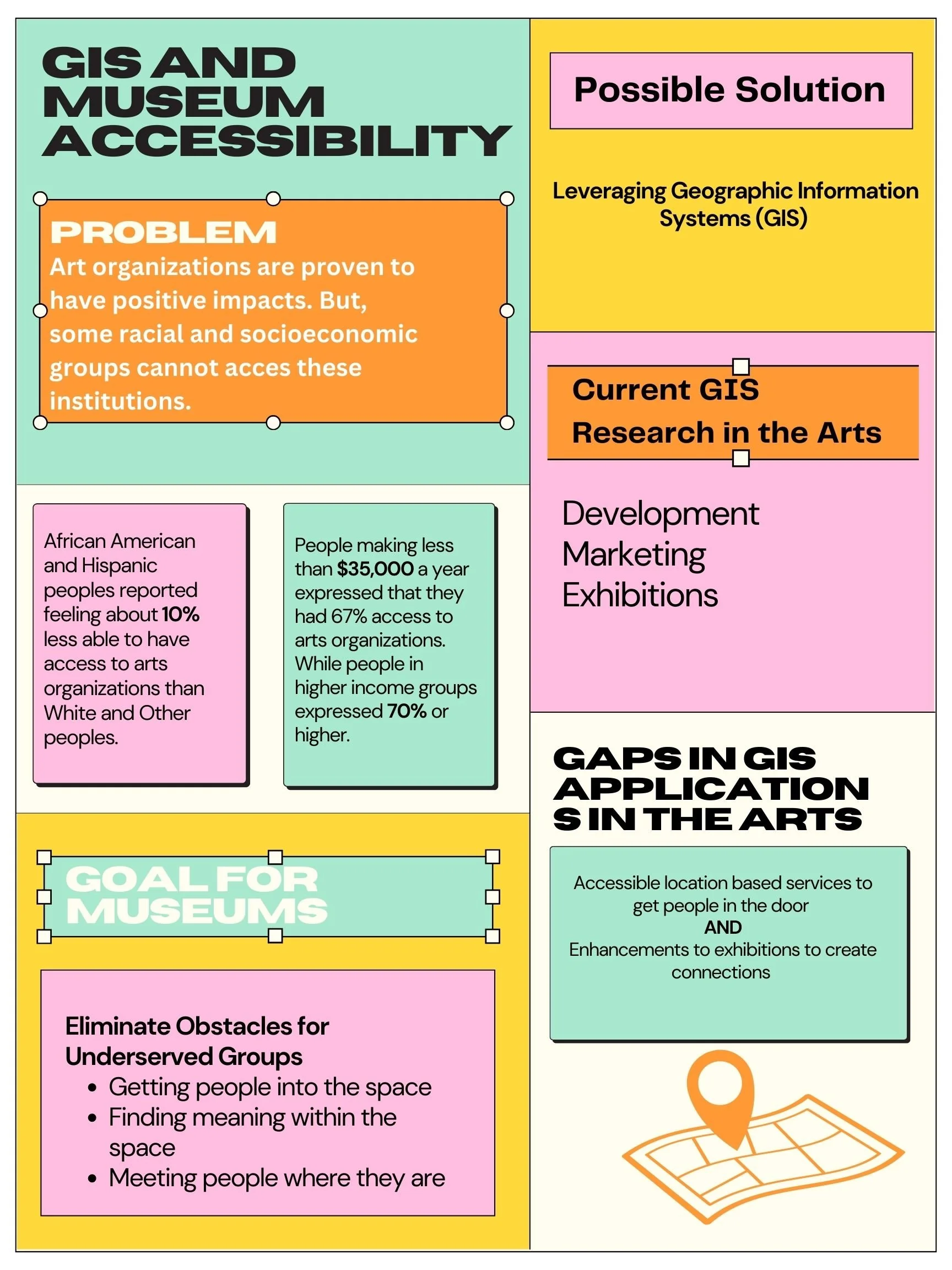
Figure 2: Infographic source: Author
GIS according to Esri is, “[...] a system that creates, manages, analyzes, and maps all types of data. GIS connects data to a map, integrating location data (where things are) with all types of descriptive information (what things are like there)”. Through the use of GIS organizations can benchmark data to find trends in the context of location. The output of GIS projects can be used internally for research and program creation, as well as externally for sharing data with the public. GIS can and has been applied to a plethora of industries, such as healthcare and government. Moreover, GIS has been used in community planning and development. Case studies discussed in “GIS and Site Suitability for Sustainable Residential Communities: Three case studies from the USA” explore the benefits of GIS outputs for decision making in city planning projects.
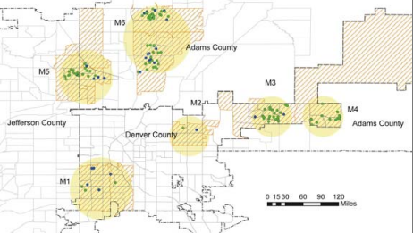
Figure 3: An Example from “GIS and Site Suitability for Sustainable Residential Communities: Three case studies from the USA” in Denver: Looking at Renovated Parts of the City Compared to Unrenovated areas
GIS is a relatively new strategy in the arts. Arts professionals and cultural organizations have utilized GIS to enhance development, marketing, and exhibitions. Jana Fredricks’ research focused on GIS and its applications in development for arts organizations. Fredericks formed a case study, “Geographic Analysis of Nonprofit Data: A How To Case Study” to provide an instructional guide on how arts organizations can input their donor data into a GIS system to find giving patterns. She also led a podcast titled “GIS and Fundraising”. in which she interviewed GIS expert Kristen Kurland about her use of GIS to amplify fundraising within their own organization. In terms of marketing applications, the American Alliance of Museums’ article, “Turning Geo-Spatial Museum Data into a Soft Power Evaluation Tool”, discusses a GIS program that can be used to evaluate characteristics of museums that engage constituents. The program uses data from several areas of museum operations in order to analyze where connections with visitors are being made.
The Museum Computer Network hosted arts professionals at their conference to discuss GIS and exhibitions in 2019. Several presenters discussed two case studies where GIS was helpful in a podcast episode, “Curating the Digital: 3D, Digitization, and Mapping. Working with Digital Teams to Create New Narratives on Emerging Platforms”. The presenters discuss the mapping work at the Smithsonian National Museum of Asian Art, both on their website and through an exhibition. The work that was done on the website of the museum used GIS to create an interactive online space so that users can explore information related to collections and museum happenings. Moreover, the exhibition, Body of Devotion: The Cosmic Buddha in 3D mapped a Chinese sculpture into a 3D replica, which gave constituents and scholars a new perspective of the object.

Figure 4: An Image of Body of Devotion: The Cosmic Buddha in 3D
GIS has also been a vital tool in the experimental project, “The Digital Pilgrim Project”. This project began in 2016 and is a collaboration between the University of Cambridge and the British Museum. Using both 3D recreation and GIS, the organizations have been able to model artifacts from the Middle Ages and then use a GIS to connect the spots these items were located and their presumed genesis. The research being done by this project is similar to that of Body of Devotion in that it is giving researchers and the public access to gaps in our history.
GIS Software
The applications of GIS are vast and constantly being used in new ways. Museums can utilize the technology to eliminate obstacles individuals face in getting into museums and barriers to finding meaning in these spaces. In order to create GIS projects within its space, a museum would have to adopt a GIS system that would best fit its organization. The GIS software available currently has vast price differences, from free to annual costs of around $20,000. Besides budget concerns, each GIS software has different benefits depending on the needs of the respective project. For the purpose of this article, ArcGIS Pro, PolicyMap, QGIS, and Simple GIS Client will be analyzed given their experience with industries related to the arts.

Figure 5: Infographic of GIS Software Available Currently: Source: Author
Many forms of accessibility are becoming a focus in the museum space. The continuation of this research will explore how GIS can be leveraged to get people into museums and create increased meaning and connection for visitors inside the space. In order to craft a comprehensive argument, this article will be made up of expert remarks and practical research on GIS software for use in museums. To support expert interviews, this article will additionally utilize case studies that intersect GIS and museums, as discussed above, to gain a well-rounded understanding of GIS potential in the field.
-
“Arcuser Online.” Augmented Reality & GIS, https://www.esri.com/news/arcuser/0311/augmented-reality-and-gis.html.
“Body of Devotion: The Cosmic Buddha in 3D.” Smithsonian's National Museum of Asian Art, 25 Mar. 2020, https://asia.si.edu/exhibition/body-of-devotion-the-cosmic-buddha-in-3d/.
Cole , Daniel G. “Incorporating Museum Collections into GIS Research” . Esri, https://proceedings.esri.com/library/userconf/fed16/papers/fed_126.pdf.
“Community Ties: Understanding What Attaches People to the Place Where They Live.” Knight Foundation, https://knightfoundation.org/reports/community-ties-understanding-what-attaches-people-to-the-place-where-they-live/.
“Curating the Digital: 3D, Digitization, and Mapping.” MCN, https://mcn.edu/resources/curating-the-digital-3d-digitization-and-mapping/.
“Esri GIS Solutions for Museums .” Esri , Esri , https://www.esri.com/content/dam/esrisites/sitecore-archive/Files/Pdfs/library/brochures/pdfs/museumbro.pdf.
Fredricks, Jana. “Geographic Analysis of Nonprofit Data: A How To Case Study.” Arts Management & Technology Laboratory , Carnegie Mellon University , https://static1.squarespace.com/static/51d98be2e4b05a25fc200cbc/t/5d485c67f4bb2c0001af9a8d/1565023336589/Fredericks-Using+Geographic+Data+to+Understand+Donors.pdf.
Grincheva, Dr. Natalia. “Turning Geo-Spatial Museum Data into a Soft Power Evaluation Tool.” American Alliance of Museums, 7 May 2019, https://www.aam-us.org/2018/12/05/turning-geo-spatial-museum-data-into-a-soft-power-evaluation-tool/.
“Home.” PolicyMap, 13 Oct. 2022, https://www.policymap.com/.
“Introduction to Arcgis Pro.” Introduction to ArcGIS Pro-ArcGIS Pro | Documentation, https://pro.arcgis.com/en/pro-app/latest/get-started/get-started.htm.
Iyengar, Sunil .“Taking Note: Arts Organizations and Community Attachment.” Taking Note: Arts Organizations and Community Attachment, https://www.arts.gov/stories/blog/2020/taking-note-arts-organizations-and-community-attachment.
Jeffs, Amy, and Gabriel Byng. 2017. “The Digital Pilgrim Project: 3D Modeling and GIS Mapping Medieval Badges at the British Museum.” Peregrinations 6 (2): 80–90. https://search-ebscohost-com.cmu.idm.oclc.org/login.aspx?direct=true&db=asu&AN=127326739&site=ehost-live&scope=site.
Kowach, Ashley. “Podcast: Gis and Fundraising, an Interview with Kristen Kurland.” AMT Lab @ CMU, AMT Lab @ CMU, 16 Aug. 2022, https://amt-lab.org/podcasts-interviews/2019/2/gis-and-fundraising-an-interview-with-kristen-kurland.
Malinverni, Eva Savina, Roberto Pierdicca, Francesco Di Stefano, Roberto Gabrielli, and Alessandra Albiero. “Virtual Museum Enriched by Gis Data to Share Science and Culture. Church of Saint Stephen in Umm Ar-Rasas (Jordan).” Virtual Archaeology Review 10, no. 21 (July 2019): 31–39. doi:10.4995/var.2019.11919.
“Qgis.” Welcome to the QGIS Project!, https://www.qgis.org/en/site/.
Reeser, Devon. “Five Ways to Use GIS to Strengthen Your Nonprofit Fundraising.” GIS Lounge, 27 Oct. 2014, https://www.gislounge.com/five-ways-use-gis-strengthen-nonprofit-fundraising/.
Richardson, Doug. “GIS and Public Policy.” Esri, 11 July 2019, https://www.esri.com/about/newsroom/arcnews/gis-and-public-policy/.
Rogers, Will. “From Reactive to Proactive: How GIS Is Helping TPL Lean into Leadership.” Harnessing Technology to Accelerate Land Protection: GIS at The Trust for Public Land. Lincoln Institute of Land Policy, 2019. http://www.jstor.org/stable/resrep22064.7.
Simple GIS Software. “Lightweight Yet Powerful GIS Software.” Simple GIS Software, https://simplegissoftware.com/simple-gis-client.
Staff. “10 Best GIS Software in 2022 (Geographic Information Systems).” COFES.COM – Make All the Right Business Moves., 27 July 2022, https://cofes.com/gis-software/.
Stein, Robert. “Museums and Public Opinion: Exploring Four Key Questions about What Americans Think of Museums.” American Alliance of Museums, 25 July 2018, https://www.aam-us.org/2018/01/20/museums-and-public-opinion/#:~:text=National%20public%20opinion%20polling%20shows%20that%20Americans%20overwhelmingly,of%20lawmakers%20who%20take%20action%20to%20support%20them.
Ufer, Tim. “The Relationship between GIS and Marketing.” USC GIS Online, 10 Feb. 2021, https://gis.usc.edu/blog/marketing-and-gis-relationship/.
“What Is GIS?” Geographic Information System Mapping Technology, https://www.esri.com/en-us/what-is-gis/overview#liSwitcher.